Lemurian Lake
Type: Natural object Kind: Water
Country: Ukraine Region: Kherson region
Availability: Available for visits, Bad road (during any weather, can be driven by two-wheel drive cars)
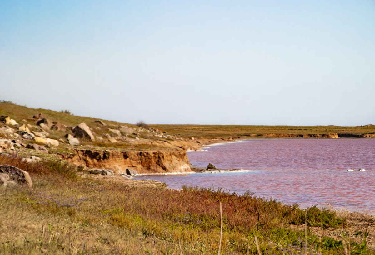
Lemurian Lake is an amazing place in the south of Ukraine. The lake is located near the Grigorovka village, Chaplynsky district, Kherson region. It is also called the Lemurian Sea, Pink Lake.
In fact, the Lemurian Lake is the Western Sivash, separated from the Central by the Kugaran dam. The lake area is about 350 km2.
Among the local population and, as a result, in the network, a legend about the origin of this magical lake exists.
It appeared in the distant 60s, thanks to a powerful explosion of a bomber, which at the time of the accident was carrying full ammunition. From the explosion was formed pit. Since the crash site was at Sivash, over time the funnel formed was filled with water. Well, then nature has made its own amendments, following which we have a real Ukrainian dead sea no worse than its counterpart, and people began to notice amazing things happening to them after swimming in pink salty water.
This is all very nice but has nothing to do with reality. Even if you do not take into account that during the Second World War, a lot of different things fell here …
A year later, I learned the details. It turned out that in this situation, the talks were about a specific pit on the lake. The diameter of the pit about 20 – 40 meters. And the dirt from the bottom of this pit is certified as curative. Activists are actively developing the tourist potential of the pit – they say that the mud from other parts of the lake does not have such healing power.
The history of Sivash and Lake Lemurian, in particular, is much more interesting and longer:
In very ancient times (at the end of the Neogene period) on the site of the Sivash there was a lowland – the Sivash trough with salty lakes. The terrain was carved with gullies and ravines.
During the Great Ice Age, there was no ice shell in this area, but the humidity has greatly increased. This led to an increase and a subsequent merging of the lakes. The result was an almost bland big water.
After the end of the Ice Age, due to the temperature increase, the water from the future Sivash began to evaporate faster and the salt concentration increased respectively.
It would have dried completely, if about 7,500 years ago the Bosphorus Strait 2 did not form and the Mediterranean Sea waters did not fill the Black-Azov sea basin. Actually, thanks to that, the Sivash has such interesting outlines – water filled the ravines and beams.
For the next 7,500 years, the level of the Black and Azov Seas has greatly changed and thereby changed the relief of coastal land. In addition, the crust in the Sivash region systematically descended, which contributed to the bay increase.
Approximately 800 – 850 years ago, the Arabat Spit took its present position and almost completely isolated the Sivash from the Azov Sea. Arabat Spit initially formed far from the coast under the influence of waves (like dunes in the desert). The same waves dragged it past the Kerch Peninsula to its present position. As a result Sivash received the rapid salinization in the absence of a large supply of fresh water. 1
Newest history of the lake2:
The extraction of mineral salts in Sivash (especially cooking salt) was carried out more than 1000 years ago, as evidenced by the remains of ancient salt mines in the southern part of Sivash. According to the salt department of the Tauride province: in the early 20th century. up to 1.8 million poods (28.8 million tons) of high-quality cooking salt, which was highly valued in the salt market of Europe, especially in the Scandinavian countries, were mined in the Sivash salt mines.
Starting from 1875 (when the railway was built, connecting the Crimea with the center of the empire and hundreds of salt fields opened) and until 1948, intensive research was conducted on the Sivash Basin.
Active human activities in the 60s – 70s, and especially the construction and operation of the North-Crimean Canal, made significant adjustments to the use of the resource potential of Sivash.
In order to increase the salt potential of the Sivash, the West and Middle ponds were separated from the East by earthen dams (Kugaran –the fully closed one and Biyuk-Nayman with a gateway in the central part), with the help of which the hydrochemical regime and supply of brine is regulated in these parts of Sivash. Thanks to these dams, the Western pond is transformed into an isolated basin with adjustable hydrological and hydrochemical regimes, and the “Middle” or “Central” pond was transformed into a huge evaporative pool for obtaining high concentration brines.
The development of the chemical industry in Prisivashye led to the need of transformation of the Western part of Sivash Bay into a series of isolated technological reservoirs through the construction of artificial dams. The Western Sivash, which previously represented a giant wind dryer (Kugaran drought), was turned into an evaporating reservoir with a more or less constant level.
On the basis of the mineral wealth of Sivash, the following factories were built: Perekopsky bromine, Crimean titanium dioxide with the manufacture of phosphate fertilizers and Crimean soda.
The Crimean Soda Plant is located in the town of Krasnoperekopsk, on the northern shore of Lake Staroe. Industrial effluents from this plant are discharged in the northern half of Lake Krasnoye, separated by a dam and converted into a storage-evaporator. This storage is filled with waste, including ferrous and non-ferrous metal scrap, plastics, household waste, ceramics, wood, glass, soda, gypsum, limestone, etc.
Perekop bromine plant is located near the soda plant in Krasnoperekopsk. The bromine plant produces commodity bromine and related preparations, using Sivash’s brine as a raw material. The plant also discharges industrial effluents into the reservoir into Lake Red and, partially, into Lake Old.
The main part of the waste is dumped into the acid accumulator-evaporator – the Sivash Bays between Hell and Lithuanian islands, it contains various acids, thousands of tons of titanium dioxide, hundreds of tons of manganese, tens of tons of chromium and zinc, and other metals.
Color and mineral composition.
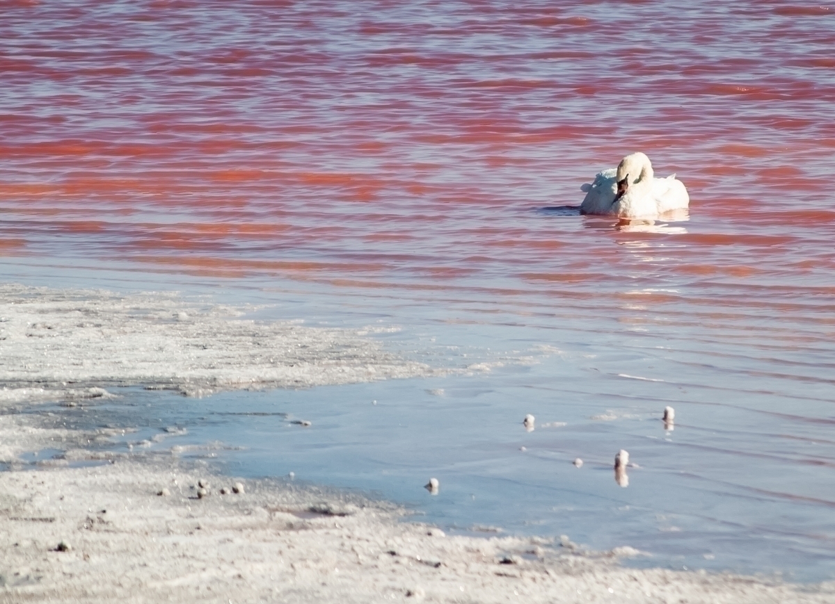
The concentration of salt in the water of the lake creates ideal conditions for the life of three types of protozoa called gallophiles (salt lovers, if literally): Dunaliella salina algae, Salinobacter ruber bacteria, protozoa archaea (Archaea). Such a degree of salinity is a necessary condition for their life. The production of carotenoids (beta-carotene) neutralizes the effects of active sunlight on these microorganisms. Exactly these protective mechanisms of the simplest are determining the color of the water – bright pink, scarlet and other similar shades.
The time of dam construction and, consequently, an increase in salt concentration in the western part of Sivash (Lake Lemurian), approximately coincides with the tales of local residents about changing the lake. There is a high probability that protozoa brought by migratory birds during this period were able to multiply in the lake due to the increase in salt concentration in it. Or maybe it was pink before that. The most likely carriers are pink flamingos, which stop in their flights and even nest on the Sivash and the western coast of the Azov Sea, which also has a pink lake. Their main diet consists of carotenoid-rich simple algae and all kinds of small crustaceans, worms and mollusks. The carotenoids in the basic version give the flamingo the same unique pink color.
At the moment I was not able to find out when the lake turned pink exactly. But I will continue my search.
Undoubtedly, technogenic activity has already led to irreversible consequences, which have practically destroyed the basin’s biocenosis. But, in the opinion of many environmentalists, it is possible to achieve excellent results by switching chemical production to non-waste technologies and slowly and accurately neutralizing stored waste. The tourist and recreational potential of the Sivash Basin is enormous. It remains to implement it))
1 Source 1.
2 E.E.Sovga, E.Schurova – Marine Hydrophysical Institute of the National Academy of Sciences of Ukraine, Sevastopol, “Resource potential of Lake Sivash and the current ecological state of its water area”, 2013


